Understanding the technology behind accurate land surveying
Land surveying has evolved dramatically from the days of chains and theodolites. Today's surveyors use sophisticated electronic equipment that can measure positions to millimetre accuracy. Understanding this technology helps explain how surveyors achieve such precise results for boundary surveys, subdivisions, and engineering projects. This guide explores the equipment used in modern surveying.
GNSS technology, commonly called GPS (though GPS is technically just the American system), has revolutionised surveying. Modern survey-grade receivers can determine positions to within a few millimetres under the right conditions.
Survey GNSS receivers track signals from multiple satellite constellations:
By tracking signals from 20 or more satellites simultaneously, survey receivers can calculate precise positions. However, raw satellite positions are only accurate to several metres. Survey accuracy requires additional techniques.
RTK is the most common method for achieving centimetre-level accuracy. It works by:
RTK GPS is ideal for detail surveys, construction setout, and any work requiring fast, accurate positioning over large areas.
Continuously Operating Reference Stations (CORS) provide corrections via mobile internet, eliminating the need for a physical base station. In Western Australia, Landgate operates the CORSnet-West network, providing RTK corrections across the Perth metropolitan area and regional centres.
Despite its capabilities, GNSS has limitations:
For these reasons, surveyors use GNSS alongside other equipment.
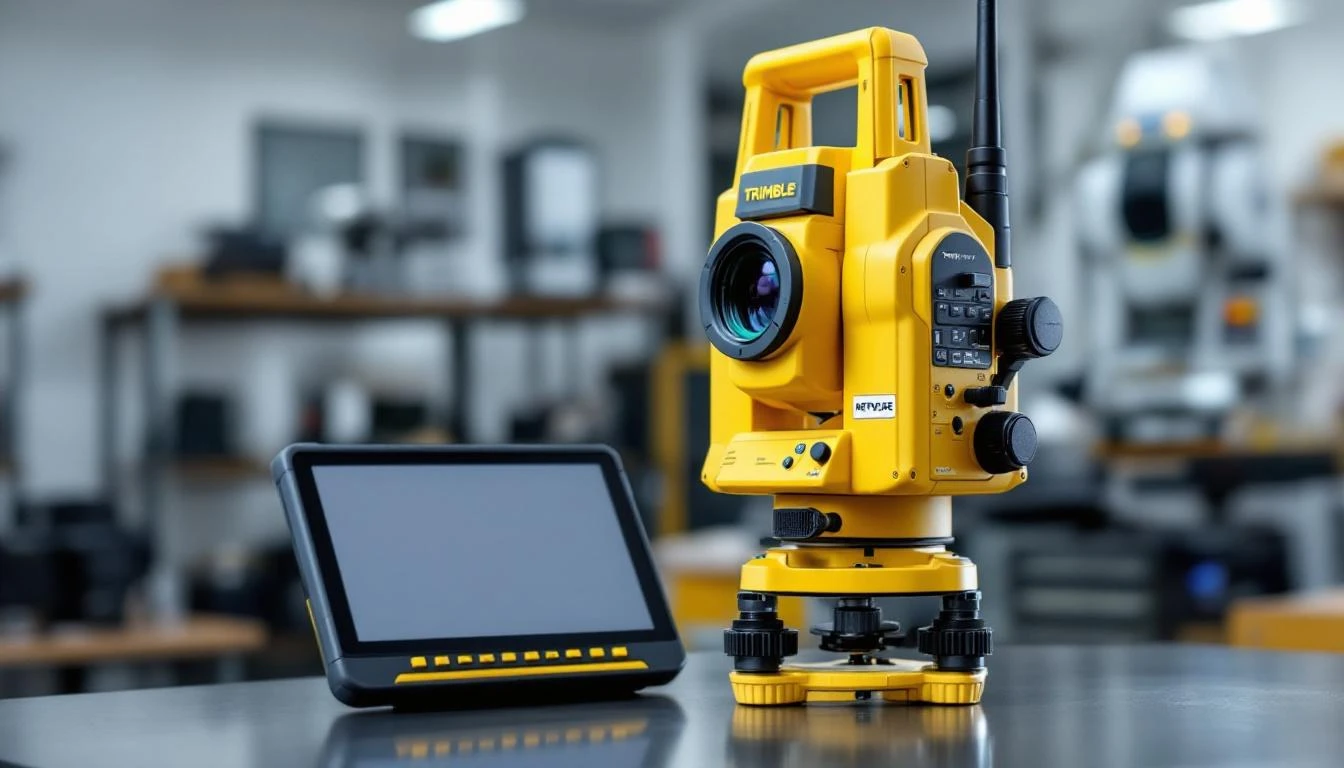
The total station is the workhorse of modern surveying. It combines electronic distance measurement (EDM) with angle measurement to determine positions with millimetre precision.
A total station measures:
Combined, these measurements calculate the precise 3D position of the target point relative to the instrument's location.
Total stations excel in situations where GNSS cannot work:
Modern robotic total stations can automatically track and follow a moving prism, allowing one-person operation. The surveyor carries the prism while controlling the instrument remotely via a handheld controller. This dramatically improves efficiency, particularly for detail surveys and setout work.
3D laser scanning (also called LiDAR or high-definition surveying) captures millions of measurements per second, creating detailed 3D point clouds of buildings, terrain, and infrastructure.
A laser scanner rapidly rotates a laser beam, measuring the distance to every surface it hits. Modern scanners capture over a million points per second at ranges up to several hundred metres. The result is a dense 3D model of the surveyed area.
3D scanning is particularly valuable for:
Drones equipped with cameras and sensors have become valuable surveying tools, particularly for large areas and difficult terrain.
Surveying drones typically use one of two methods:
Photogrammetry: The drone captures overlapping photographs which are processed using specialised software to create 3D models and orthophotos (geometrically corrected aerial images). Accuracy depends on ground control points surveyed with traditional equipment.
LiDAR: Some drones carry laser scanners for direct 3D measurement. This is particularly useful for surveying through vegetation as the laser can penetrate tree canopy to measure ground levels.
Drones are ideal for:
Drone surveys have limitations including:
Despite modern technology, some traditional equipment remains relevant:
Optical and digital levels are still used for precise height measurement, particularly for construction setout, floor levelness checks, and drainage work. Modern digital levels can read special barcoded staffs automatically, improving speed and reducing errors.
For short measurements, particularly inside buildings for strata surveys, measuring tapes remain practical. Digital distance meters (laser measures) have largely replaced tapes for most purposes.
Modern surveying relies heavily on software for:
The combination of precise field equipment and sophisticated software enables surveyors to deliver accurate, reliable results for every type of survey project.
Professional surveying firms invest significantly in high-quality equipment for several reasons:
When you engage a professional surveyor, you're not just paying for time - you're accessing the technology and expertise needed to deliver precise, legally defensible results.
Our team uses the latest surveying technology to deliver accurate results for all project types. Contact us to discuss your survey requirements.
Get a Quote Call (08) 5122 5501Experience the precision of professional surveying equipment and expertise.